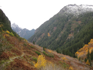


 Perry Creek is a beautiful fall hike with a taste of winter thrown in. The short but steep trail (8 miles round trip, 3200' elevation gain) begins under the sheer cliffs of Mount Dickerman's west face, a nearly 2 mile long avalanche chute between the trailhead and the falls. Few evergreens grow here, swept away by annual avalanches and occasional rock slides, but the alders and vine maples abound, dappling the trail with yellow, orange, red and gold, and expansive openings reveal views of Big Four, Hall Peak and a half dozen waterfalls across the valley.
A good trail procedes over stable rock on a gentle grade at first, gradually steepening in the second mile until you reach old growth forest at Perry Creek falls. Just past the falls is a creek crossing, partly on rocks, partly on a large downed cedar log, easy today but it could be tough if the creek was any fuller. Stepping on the partly submerged rocks, the water came within an inch of my boot tops. If your unsure, it might be worth putting on gaiters to keep the very chilly water out.
From here, the trail begins to climb steeply up the side of Mount Forgotten. Although easy to follow, it is a root and rock strewn path that keeps your eyes focused on the trail, just as well since the views have vanished, but it's worth stopping now and then to examine the large trees above and the interesting fungi below. Try not to get discouraged at the steep slope that seems to go endlessly up.
After gaining 2000' in the next 2 miles the ridge is finally attained. On this late October day we reached snowline at about 4500' elev., and found 2 inches of snow dusting the top. Great views here of Dickerman, Forgotten, Big Four, Hall & Stillaguamish Peak's. Another 300' gain in less than a quarter mile brings you to Mount Forgotten's meadows, but any wildflowers were long since bloomed and burried under snow.
If the creek crossing was a bit dodgy on the way up, be sure to keep an eye on the weather as this small, narrow creek will fill up fast in a heavy rain.


