My hikes in Wasington State. This is not intended as a guidebook, just my description of some of the wonderful trips and trails you can enjoy here. For actual trip planning, get details from a source like wta.org, trails.com or one of the excellent books published by the Mountaineers.
Tuesday, June 23, 2009
Barlow Point
After hiking the much too crowded Lake 22 trail (we'd hoped the rain would keep the crowds away, but it didn't, not even the woefully unprepared sneakers and sweatshirt people), so we went on an additional hike to Barlow Point.
The trailhead is at Barlow Pass. A hike of 1.2 miles and 800' elevation gain, this moderately easy trail starts by going slightly down hill under a long rock wall (pretty hanging purple flowers here...penstamon?), then begins a series of switchbacks with no level areas (those not used to hiking might need to pause for a breather on the way) through a forest of second growth timber. This is a fairly boring trail, with little understory vegetation, mostly sticks and fir needle duff on the ground, but can be a great educational walk when showing friends why clearcuts are bad forestry, a mirror opposite of the lush and lovely Lake 22 Research Natural Area.
There's no lake or stream on the way, and no views to speak of. So why bother?
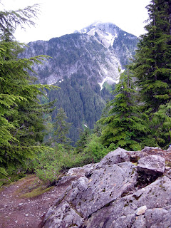
Because when you reach the site of an old fire lookout at the top of this 3200' knob, you'll find lovely views up the Sauk river towards Mt. Pugh, across to Sheep Mountain, and down the Stillaguamish to Big Four and Hall Peak, as well as Twin Peaks and Mt. Dickerman. The rocky summit provides nice "chairs" to lounge on, and unlike other hikes in the neighborhood you'll probably have the trail to yourself.
On the return trip, turn off at the trail marked "Railroad Grade" and follow the path of the old Everett & Monte Cristo Railway back to the trailhead parking lot.
Monday, June 15, 2009
Deception Creek
We chose Deception Creek because it was a day of low clouds and little visibility, and there are no real views on this trail, except for a brief glimpse of Spark Plug Mountain from a landslide-opened area at about 3 1/2 miles. The trail and the creek the "view" here. You enter the Alpine Lakes Wilderness in about 1/2 mile and begin a slow but steady climb, above and away from the creek, but always within earshot.
After 3 miles you've already gained most of your elevation for this hike. The creek again makes contact with the trail, and there are supposedly camp sites here, but they were still under snow as of this date. Intermittent snow covers the trail in places from here on, becoming continuous at about 4 miles until you reach Fisher Creek at 5 1/2 miles. Deception Creek was awesome on the second half of the trail, narrowing into ravines, tumbling over pools and basins, with so many waterfalls I lost count. At Fisher Creek it is possible to cross on downed logs and continue to Deception Lakes & Pass, but that would require an overnight trip, so this is a good turn around for a day hike, round trip of about 11 miles.
A big shout out to our fellow WTA members who built a number of bridges, large and small, along this trail. We stayed safe and dry. Thanks volunteers!
When you're done, don't forget to stop at the nearby Deception Falls viewing area, just west of the trail on the north side of HWY 2. It's a short trail, just a few hundred feet, and the falls are quite impressive there.
Goat Lake
Happy day! Barlow Pass is now open!
The Goat Lake trail is in great shape, snow free and free of blowdowns the whole way. Since there is a lower and upper trail here, we did this hike as a loop, starting with the lower trail, which follows Elliot Creek through a forest that ranges from slide alder to tree farm to old growth, turning into a towering stand of ancient sentinals as you enter the Henry M. Jackson Wilderness. Elliot Creek makes a nice waterfall at the lake's outlet and was running so full of snow melt that it looked more like Elliot River.
At Goat Lake we found low clouds obscuring views of Cadet Peak and the aptly named Foggy Peak, so we bushwahcked on a faint tred along the north side of the lake to a view of yet another waterfall. The temperature dropped into the low 50's as a light rain began to fall, cool enough that I actually fished my gloves out of my pack for a few minutes. Typical "June-uary" Cascades weather. We did finally get a short sun break and the clouds briefly parted revealing Cadet Peak rising from the lake's east end.
We returned via the upper trail, an old logging road through a mostly alder forest, with occasional views of Sheep Mountain and passing by numerous small waterfalls. This segment of the trail has lots of flowers like trillium, bleeding heart and red columbine, and a couple nice moss & fern gardens clinging to wet rock walls.
Total trail distance for our trip was 12 miles, 1400' elevation gain. If you want to camp here, come early or come during the week, Sunday it was full of campers.
Subscribe to:
Posts (Atom)